O Atlas Fotográfico de Berlim
Entre 2021 e 2022, com auxílio do Instituto Goethe e do DAAD, realizei um projeto artístico e experimental chamado Atlas Fotográfico de Berlim. O trabalho consiste num levantamento fotográfico da região metropolitana da cidade, baseado num projeto semelhante que realizei em São Paulo.
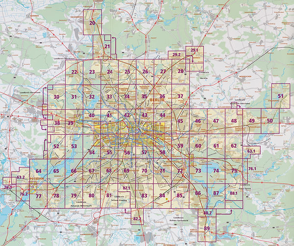
O resultado são 70 fotografias, produzidas a partir de um rigoroso método prático e teórico. Basicamente, realizei uma fotografia correspondendo a cada página do guia de transporte da cidade Berlin Atlas BVG 2021. Isso me permitiu (ao menos conceitualmente) percorrer todas as regiões da cidade na busca de responder à seguinte pergunta: “como representar esses imensos e complexos territórios em sua extensão e diversidade?"
O método me obrigou a percorrer tanto o centro quanto as áreas mais afastadas, indo a lugares para onde eu jamais iria de outra forma. Realizei quase todos os deslocamentos utilizando a fabulosa rede de transporte público de Berlim e, tendo permanecido alguns meses na cidade, pude fotografar tanto no verão quanto no inverno. Com isso, as fotografias apresentam uma grande diversidade de paisagens e cenários urbanos.
Como o nome sugere, o Atlas Fotográfico aproxima-se do universo de mapas, guias e outros objetos da cartografia, e pretende ser um instrumento de orientação nesses vastos territórios urbanos. Conceitualmente, o trabalho foi guiado por um livro clássico do urbanismo. Em A Imagem da Cidade (1960), o professor americano Kevin Lynch sugere que, se não conseguirmos ler a cidade adequadamente, não conseguiremos agir sobre ela. E se não conseguirmos agir sobre ela, criaremos uma experiência alienada. Portanto, a “legibilidade” da cidade é um requisito para a participação social e política – um problema que se torna ainda mais sério no mundo contemporâneo, onde a experiência direta é cada vez mais substituída pela virtual.